
Precision Timing from Satellites: How It Powers Navigation, Communication, and Global Operations
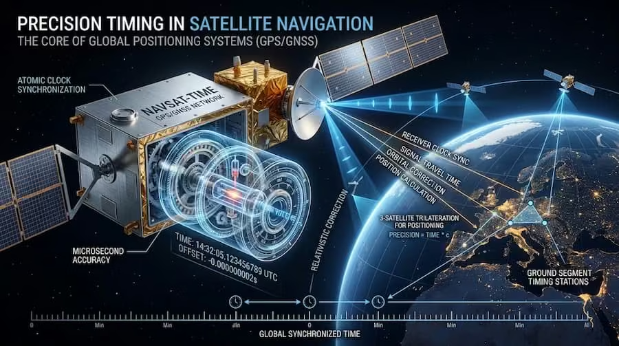
Precision timing from satellites enables accurate GPS navigation, communication networks, and critical global operations worldwide.
Satellites play a far more critical role in modern life than most people realize. Beyond providing internet access or television signals, they deliver something far more fundamental: precision timing. Accurate time signals from space form the invisible backbone of navigation systems, global communications, financial markets, power grids, and emerging technologies. In fact, precision timing from satellites has become one of the most essential infrastructures supporting today’s connected world.
Without satellite-based timing, GPS would lose accuracy within minutes, mobile networks would struggle to stay synchronized, and high-frequency trading systems would face serious disruptions. The reliability of modern digital systems depends heavily on precision timing from satellites, which ensures that devices and networks across the globe remain perfectly aligned. From aviation and shipping to telecommunications and emergency services, countless industries rely on this invisible yet powerful capability.
This article explains how satellite precision timing works, the key benefits it delivers, and how different orbital systems contribute to these capabilities. Understanding precision timing from satellites is essential for appreciating how modern technology functions at a global scale. As demand for real-time data and synchronization continues to grow, the importance of precision timing from satellites will only increase in the years ahead.
Why Satellite Timing Matters
Every second, satellites equipped with highly stable atomic clocks broadcast precise time signals to Earth. Receivers on the ground use these signals to determine exact time and, when combined with signals from multiple satellites, precise location. This process forms the foundation of precision timing from satellites, which enables highly accurate global positioning and synchronization.
The accuracy required is extraordinary. A timing error of just one nanosecond (one-billionth of a second) creates a positioning error of approximately 30 centimeters. Modern satellite clocks maintain accuracy within a few nanoseconds, enabling reliable performance across industries that depend on exact synchronization. The reliability of precision timing from satellites is what allows systems such as GPS, financial networks, and telecommunications to function with exceptional consistency.
Satellite timing also provides a trusted, independent time source that is difficult to disrupt compared to ground-based systems. This resilience makes it especially valuable for critical infrastructure. In addition, precision timing from satellites supports continuous operations even in remote or challenging environments where traditional timing sources may fail. As digital systems become more interconnected, the demand for dependable precision timing from satellites continues to grow across navigation, communication, and global operations.
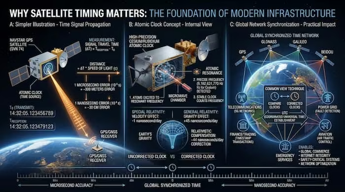
How precise satellite timing powers GPS, global networks, and critical systems worldwide.
7 Key Benefits of Satellite Precision Timing
1. Ultra-Accurate Global Time Synchronization Satellites maintain a consistent time reference across the entire planet. This allows systems thousands of kilometers apart to stay perfectly synchronized without relying solely on local clocks or terrestrial networks. |
2. Reliable Navigation and Positioning Global Navigation Satellite Systems (GNSS) such as GPS, Galileo, BeiDou, and GLONASS depend entirely on precise timing. By measuring the time it takes for signals to travel from satellites to a receiver, devices can calculate position with high accuracy. This underpins aviation, maritime navigation, logistics, surveying, and everyday smartphone maps. |
3. Synchronization of Financial and Telecom Networks Banks, stock exchanges, and high-frequency trading platforms require precise timestamps for transactions. Mobile networks (4G, 5G, and future 6G) need accurate timing so that base stations remain coordinated. Satellite timing provides a stable external reference that supports these time-sensitive operations. |
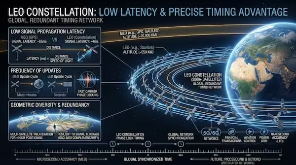
4. Low-Latency Connectivity via Low Earth Orbit (LEO) LEO satellites orbit between 160 and 2,000 km above Earth. Their proximity enables round-trip signal times of roughly 20–80 milliseconds — low enough to support real-time applications such as video conferencing, cloud services, and interactive systems. Large LEO constellations have significantly expanded access to high-speed connectivity in remote and underserved regions. |
5. Continuous Coverage Through Geostationary Satellites Geostationary (GEO) satellites operate at approximately 35,786 km above the equator and remain fixed relative to Earth’s surface. Although latency is higher (typically 240–600 milliseconds), they provide uninterrupted coverage over large regions. This makes them ideal for broadcasting, weather monitoring, long-distance communications, and emergency response systems that require constant availability. |
6. Rapid Deployment and Resilience in Crises Unlike fiber-optic or cellular networks, satellite systems can be activated relatively quickly. When terrestrial infrastructure is damaged by natural disasters or other disruptions, satellite links often restore communication and timing services faster, supporting emergency coordination and operational continuity. |
7. Enabling Emerging Technologies Autonomous vehicles, smart cities, industrial Internet of Things (IoT), and advanced logistics systems all require reliable positioning and timing. Satellite-based precision timing supplies the accurate time reference these technologies need to operate safely and efficiently at scale. |

Discover the 7 key benefits of satellite precision timing that power modern navigation, trading, telecom, and global systems.
Understanding Orbital Systems and Their Trade-Offs
Different orbital regimes offer distinct advantages for precision timing from satellites, depending on the application. Understanding these differences is essential for selecting the right system.
Low Earth Orbit (LEO) |
|
|
|
|
|
LEO systems excel in broadband internet, IoT connectivity, and high-frequency Earth observation. Their low latency makes them particularly suitable for interactive and time-sensitive services that rely on precision timing from satellites.
How Low Earth Orbit (LEO) constellations deliver low latency and precise timing for global networks
Medium Earth Orbit (MEO) |
|
|
|
|
|
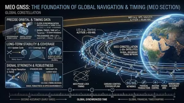
MEO is the primary orbit for global navigation systems such as GPS and Galileo. These satellites provide precision timing from satellites and accurate positioning signals used worldwide for transportation, logistics, and synchronized operations.
How Medium Earth Orbit (MEO) GNSS constellations deliver stable, robust global navigation and precise timing.
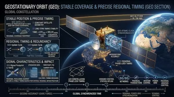
Geostationary Orbit (GEO) |
|
|
|
|
|
GEO satellites are widely used for television broadcasting, weather monitoring, long-distance telecommunications, and disaster response communications, where uninterrupted coverage is more important than ultra-low latency, supporting the broader value of precision timing from satellites.
How Geostationary Orbit (GEO) delivers fixed-position coverage and precise regional timing for critical infrastructure.
Performance Metrics That Matter
Two technical factors strongly influence the effectiveness of satellite timing and connectivity: |
Propagation Latency: This is the time required for a signal to travel between a satellite and Earth. Lower orbits reduce latency, enabling near-real-time applications. Higher orbits increase latency but offer broader coverage. |
Revisit Cadence: This refers to how frequently a satellite (or constellation) can observe the same location on Earth. Large LEO constellations can reduce revisit times to minutes, while GEO satellites provide continuous viewing of their coverage area. |
Organizations select orbital systems based on the balance of speed, coverage, reliability, and cost required for their specific missions. |
Real-World Impact Across Industries
Satellite precision timing supports a wide range of critical functions:
|
|
|
|
|
As satellite constellations continue to expand and technology advances — including optical inter-satellite links and improved atomic clocks — the performance and reliability of precision timing from satellites will continue to improve.
Conclusion: precision timing from satellites
Satellite precision timing is one of the most important yet least visible foundations of the modern digital world. From enabling accurate navigation to keeping global networks synchronized, the benefits extend across nearly every major industry. Without reliable time signals from space, many of the systems we depend on daily would face serious disruptions in accuracy and performance.
Precision timing from satellites plays a central role in supporting critical infrastructure, including financial markets, telecommunications, transportation, and emergency response systems. It provides a trusted and independent time reference that remains stable even when ground-based networks are compromised. This resilience makes satellite-based timing especially valuable in an increasingly connected and time-sensitive world.
By combining low-latency LEO systems, navigation-focused MEO constellations, and continuous-coverage GEO platforms, satellite technology delivers a flexible and resilient timing infrastructure that terrestrial systems alone cannot match. Each orbital regime contributes unique strengths, allowing organizations to choose the right balance of speed, coverage, and reliability for their specific needs.
As demand for real-time data, autonomous systems, and global connectivity continues to grow, the importance of accurate time synchronization will only increase. Emerging technologies such as autonomous vehicles, smart cities, and advanced IoT networks will rely even more heavily on precise and dependable timing sources.
Looking ahead, continued advancements in satellite technology — including improved atomic clocks, optical inter-satellite links, and larger constellations — will further enhance the performance and reach of these systems. In this evolving landscape, precision timing from satellites will remain a foundational element of global digital infrastructure.
Ultimately, the ability to deliver accurate, synchronized time on a worldwide scale is what allows modern systems to operate efficiently and reliably. As industries become more dependent on real-time coordination, precision timing from satellites will continue to serve as a critical enabler of innovation, safety, and operational excellence across the globe.